Red pillar-boxes and telephone booths with the Royal insignia are reminders of a British heritage.

If you are one of those who like direct contact with nature, in Los Glaciares National Park you can enjoy a unique and unforgettable adventure. In this park you will be able to make amazing tours through its impressive forests of ñires and lengas and you will even have the unique possibility of walking on glaciers with the help of mountain guides.
Located in the southwest of the province of Santa Cruz on the border with Chile, this park covers an area of 726,927 hectares and is considered the largest of Argentina's national parks. Due to its incomparable landscapes, its glaciological and geomorphological interest and the presence of endangered animals such as the huemul, it was declared a World Heritage Site in 1981.
The Park is divided into two large zones: North and South. The northern part of the Park includes the glacier and Lake Viedma, the community of El Chalten and mountain peaks, such as Mount Fitz Roy and Cerro Torre, both very popular with climbers and hikers worldwide.
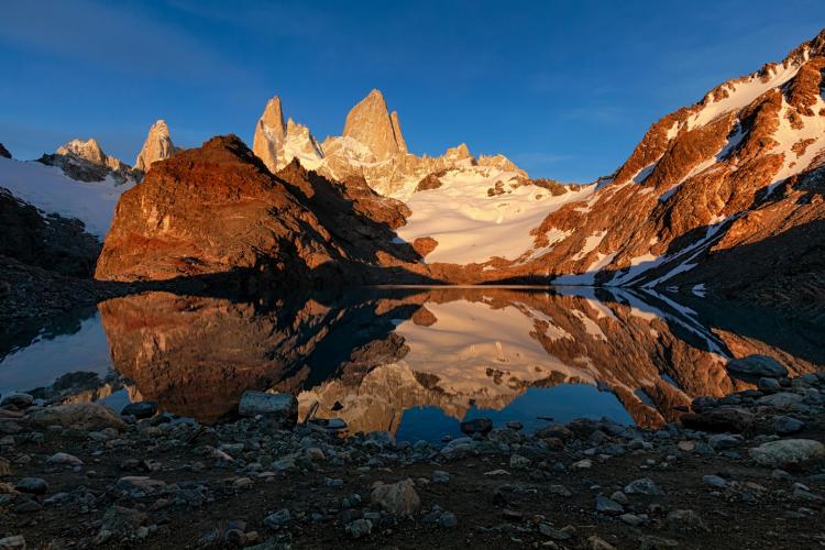
The Fitz Roy offers an imposing spectacle as its crests and edges appear between glaciers and clouds. With an altitude of 3405 meters above sea level, its climbing requires the expertise of an expert climber, because it has huge expanses of almost vertical slabs, polished and slippery, constantly beat winds of enormous force and there may be sudden changes in weather conditions during the climb. To reach its base you can take the trail from El Chaltén. This small community, known as the National Capital of Trekking, is one of the youngest towns in Argentina. Here you can find numerous tourist services.

Credits Visit Argentina
Although the Glacier National Park can be visited all year round, if you want to go hiking the best season to do so is from November to April. We recommend you always check the status of the trails at the Glaciers National Park Visitors Center located just before the entrance to the tourist village.
There are many possibilities to enjoy this Patagonian paradise! We invite you to discover some of the routes that you can follow in the northern area of the park to discover this natural wonder.
The Fitz Roy trail is a difficult route that goes deep into the Andean Patagonian forest and ends at Laguna de los Tres. This trail starts in El Chaltén and through it you will enjoy spectacular Patagonian landscapes.
The first stop is the viewpoint of the Vueltas River where you will be breathless at the breathtaking views of the valley. After the third kilometer, the road forks and you will have to choose between continuing to the Fitz Roy viewpoint or visiting the Capri Lagoon. On this route you can spend the night at Camp Poincenot. From the camp to the Laguna de los Tres there are approximately 2 kilometers of distance. The final part of the route is really steep and hard, but the result at the end of the road is impressive. In front of you you will have the imposing Fitz Roy and the Laguna de los Tres.

Mount Fitz Roy, Credits Visit Argentina
This trail is one of the classic routes to follow in the Park and has a medium difficulty. After a hike of approximately 3 hours you will reach Laguna Torre. The trail starts from El Chaltén and enters the Fitz Roy River Valley. Approximately 15 minutes after starting the hike, you can access the first viewpoint, located in a gorge of the Fitz Roy River. From this viewpoint you will be able to appreciate the valley, Mount Solo, the imposing Mount Torre, and the Fitz Roy. On the other side of the river is the Margarita waterfall. Continue the trail up the river and you will arrive at the Del Torre viewpoint (4 km), which offers an incomparable panoramic view of the Adela range, the Torre hill and the granite needles that accompany it.
If you need a place to spend the night during the trip, the trail has the DeAgostini base camp located at kilometer 8. From this camp you can descend to the Torre lagoon, or continue along the same ridge for another 2 km to the Maestri viewpoint to enjoy breathtaking views of the Cerro and especially the Torre glacier.
The trail starts at the Ceferino Fonzo Visitor Center of the National Park. The trail has a distance of 12 kilometers to the summit. During the journey you will be able to cross forests of ñires and lengas, steppe and high mountain areas. The best season to make this trip is from October to April.
This trail maintains an ever ascending slope of approximately 1100 meters in total, until you reach the viewpoint located about 1500 meters above sea level. This last part of the trail to reach the Mirador del Pliegue Tumbado is marked with yellow sticks.
If you climb to the top of Pliegue Tumbado you will enjoy an extraordinary 360 degree panoramic view.
This is an ideal trail for those who do not want to do big or difficult trails. The trail starts in El Chaltén, at the end of the trail you will find a beautiful waterfall of the same name that has a height of 20 meters.
This route starts in El Chaltén and allows access to these two viewpoints. This trail is very well signposted and is ideal if you are not trained in long hikes. First you reach the Mirador de los Cóndores and, continuing along a stretch with just a little more elevation, you reach the Mirador de las Águilas. In both it is possible to see eagles and condors flying overhead, as well as unique views of Cerro Torre, Mount Fitz Roy and its glaciers, El Chaltén, Lake Viedma and the Patagonian steppe.


Red pillar-boxes and telephone booths with the Royal insignia are reminders of a British heritage.